Summer Flight Timetable for Flights to Albania
(Version 5 Effective 05 March 2021)

ALBANIAN ALPS
Albania's Mountainous Heart
Ndërlysa
Ndërlysa’s marble pools are a result of rare rock formations. The various and irregular geometric shapes, carved throughout the centuries by the water erupting from the rocks, will leave the visitor stunned. Constantly drenched by the wild waters of the river and the snow-covered streams, these pools are the ideal place for cooling down during the hot summer months. The pool’s surface is smooth and calming, the water crystal clear and the entire environment refreshing. However, please exercise caution if visiting this site with children and make sure you supervise their movement along the unpredictable terrain.
The gigantic rocks are predominantly white with light pink veins running throughout their surface, thus lending them an even more appealing appearance and giving the entire landscape a pleasant touch. The sun is beautifully reflected on the rocks’ pale surface throughout the year, making this particular area dazzle with light. The pools rise along a long valley that is surrounded by bountiful greenery and a wonderful mountainous landscape. The melted snow from the Alps has carved away at this landscape for years, creating an incredible natural monument which seems to have been sculpted by great artists. This gorgeous attraction is located in the peripheries of the northern village of Theth and become visible after you descend Theth Valley.

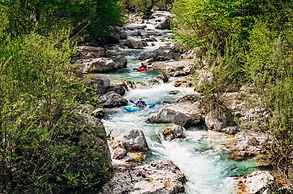
Shala River, Lumi Shales
Shala’s River is a touristic destination that is described by many visitors as the most beautiful pearl of Koman’s lake, as Thailand of Albania . The hazy colour of water and its crystal clean water is characteristic of this river. The steep huge rocks, worn by trees and green plants, seem to rise to the sky to protect this beauty that so generously mother nature has offered to our eyes and hearts. Reachable only by boat and surrounded by mountains, this river is a perfect getaway for those who want to get rid of the mobile connection.
The source of this river is in the Albanian Alps. Lumi i Shalës is a river flowing inside the Albanian Alps. Its source is in the Okol, near Radohina peak in Theth, close to the border with Montenegro. It flows into the Koman Reservoir Lake. The length of this river is 36 km. There are two main Guest Houses there. One is called Blini Park and the other one is Eagles Land. There you can find a place to sleep, local food and a bar with drinks. If you are a fan of camping, there you can find many camping spots as well.


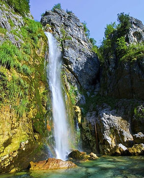
Grunas Waterfall
Situated in the Albanian Alps, this rare result of melted snow waters offers adventurers one of the most rewarding hikes and climbs in the northern region of the country. The Grunas Waterfall is located in the surroundings of Theth, a village located only 75 kilometres from the city of Shkodra. Its water falls in a thin strip form a height of 30 meters, moving through rocks sculpted by the unstoppable flow of water throughout the centuries.
Breathing the clean air and gazing at this landscape. It takes approximately an hour to get the waterfall from the centre of Theth Village. The hike is spectacular, taking you along a spectacular landscape of rivers, pastures, and mountain slopes. The last leg of the hike involves a 15-minute climb of an intermediate level. This waterfall is part of the numerous water sources in Theth. The alpine mountaintops surrounding the Shala commune, covered by snow year-round, are the main source of water for the Grunas Waterfall. Indeed, this waterfall’s water derives entirely from snow water! During the milder seasons of spring, summer and fall, the waterfall is a mustsee destination of the gorgeous Albanian north, a still mostly untouched region. This beautiful natural monument has been protected by the state since 2002.
The waterfall is a point of pride for the inhabitants of Theth as it never ceases to amaze the throngs of visitors that come to see it. The flowing water creates an emerald pool at the bottom which completes the rare beauty of this part of Theth. The cliffsides of the waterfall offer another great opportunity for those who would like to see the springs of the Grunas Waterfall.
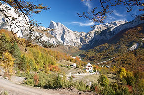
Theth National Park
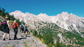
Nestled amongst the Albanian Alps, Theth National Park covers a vast and sprawling area of 26.3 square kilometres. It must be said that Theth is not for the weak-hearted, and we do mean that! Getting there is the trick and any enthusiastic tourist can choose one of two quite varied journeys. The first is the most comfortable, this route is by car and takes you through Shkodra. You do get the views from your vehicle but it’s not exactly the full Theth experience. That brings us to the second journey, this one is by foot, it’s much more demanding but unquestionably more rewarding.
This 6 to 7-hour journey involves climbing the Valbona Pass by foot, and do not take it lightly. Two spectacular peaks loom above Theth National Park: Jezerca and the Accursed Mountains. Once upon a time the latter was famed for housing nymphs, goddesses and other mythical beings. The gorgeous spectacle of the Shala River flowing and meandering through the area, is truly something to behold.
You’ll find water features aplenty in the vicinity and it goes without saying that the Waterfall of Grunas (or Theth) is an impressive sight with a 30m high cascade of plunging water. The rugged and narrow canyon of Grunas in close proximity adds to the magical atmosphere, with crystalline waters running through it for more than a kilometre. Upon crossing the canyon, a 30 to 40-minute hike will take you into the heart of the village Ndërlys. It’s in this village that you will discover Vaskat e Gurit (literally ‘Stone Bathtubs’), awe-inspiring rock formations carved out by the Black River set amongst crystal-clear turquoise waters.
The Black River descending from the village of Kaprre, creates yet another majestic pool: The Blue Eye of Theth. With a rich-blue hue and surrounded by lush greenery, it’s a magical sight. A calm stream descends from the mountains above, an abandoned tower adds a finishing touch to this gorgeous and remarkable location. Do not fear, there are plenty of rest spots along your journey where you can relax and recuperate some energy. Roast lamb, warm homemade bread, cheese, yogurt, butter, honey and all manner of homegrown fruits and vegetables are there for your mid-hike cravings, masterfully prepared and served by the families of the nearby guesthouses.


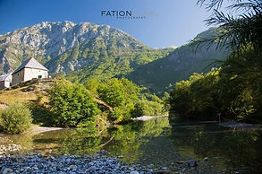
Church of Theth
The ruins of the old church date back to the year 1892 and it was precisely here, in the same location, that the new church of Theth was erected. As modest as it is striking, this church is inextricably linked to the image and history of the scenic village of northern Albania. Long ago, the first parishioner of the church lived right next to it, in the attached presbytery. Nowadays, however, with the reconstruction of the new church, this sacred place has become home to all the village locals, a mostly Roman-Catholic population.
The history of the church is connected to the names of various Albanian patriots and clerics who served their country and contributed to national culture. Father Shtjefën Gjeçovi, for instance, is one of the heroes behind the cultivation of the Albanian language. Back in 1917, he opened the first Albanian school in this area, a tradition which was highly supported and shared by other clerics and teachers as well as by the post-1921 Albanian government, which quickly followed suit.
During the Communist dictatorship, the church was closed though fortunately not destroyed, like many other religious structures during the time. Instead, the church assumed another function and served as a civic centre where many community services took place. After the 1990s. with the collapse of the Communist regime, Theth’s inhabitants along with their family members, who by now were immigrants in various countries in Europe, financed the reconstruction of the new church. The new church has assumed a similarly significant and dominating presence as its predecessor.
Perfectly situated on the tranquil valley, this small grey structure warmly welcomes all those who are lucky enough to visit this magical village. The construction reflects the traditional structures of the deep highlands. Resembling a tower, the entire structure rests on a single massive column, with quaint rooftops which reach varying heights, culminating with the grand cross. The back of the church is semi-circular with the various roofs enhancing the wonderful architectural harmony of this structure. The church is particularly breath-taking on early spring and summer mornings. At these moments, the especially bright Theth sunlight turns everything to a shimmering shade of silver, in the middle of which the matching silver-hued church seems to appear as if by magic.


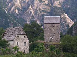
Tower of Theth
The Lock-in Tower of Theth, also known as the Tower of Nikoll Koçeku, is one of the most valued historic and architectural monuments of Albania’s highlands. A unique structure that contains hundreds of years of history, in the village of Dukagjin, this tower is known for having imprisoned all of those who had committed serious crimes against the Kanun of Lekë Dukagjin, a set of oral traditional Albanian laws coded in the 15th century.
Located in the centre of Theth Village, the tower is one of the main touristic attractions of the surrounding mountainous region. It has historically belonged to the Koçeku family and, in fact, one of the family’s descendants, Sokol, serves as its current guide. He can truly recount its history in full and vivid detail which usually includes an accurate and dramatic interpretation of the Kanun. The tower is a four-sided structure made entirely of stone and topped by an alpine roof, a construction which creates total isolation, typical of the country’s northern region. This type of fortress structure is widespread in the area as it provided the maximum level of defence.
The towers’ small windows, called frëngji, gave the locals an advantage over the enemy as the former were constantly aware of the movements outside of the towers’ walls. The tower contains very few furnishings, only adding to the dramatic effect of this daunting stone structure. An old wooden furnace, a few leather cloths as bedding, simple cookware and, next to them, a fire weapon, necessary for defence. The tower served as a structure of defence until fairly late, with the Communist era ultimately doing away with its original function. The Tower of Theth is mentioned by one of the most renowned Hungarian scholars, Franz Nopcsa, who ventured in northern Albania and is responsible for the very first geological map of this mountainous region.

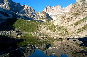
Blue Eye Theth
If you are descended from Thethi, once you pass the Grunas canyon, down to Electric Plant of Ndërlysa and walk straight over the side village of Kaprre until you reach the Black Well, which is formed by the Black River which comes down from Kaprreja, if you drive, you must stop and park there, because from Nderlysa to the Blue Eye of Kaperre there is no automobile road. Once you have parked the vehicle near the ruins of the School, appear before you the Black Well. From this place, you should depart on foot to visit the Blue Eye of Theth. Once you have passed the bridge and take the road to Kaprre, it appears before you one of the most beautiful landscapes formed by the erosion of the cliff by the river, where some bathtubs and waterfalls are created, which are the most beautiful sights in Albania.
The Blue Eye is one of the rare beauties of entire Albania. It is formed from the Black River, which flows out from the Black Top. The Blue Eye is formed by the erosion of rock by the water that descends from the mountains. The Black Well is about 100 square metres and about 3 to 5 meters of depth. The Black River is entirely formed from the melting snow in the Alps. Any tourist can go to the Blue Eye because the road lay in a plain valley. Along the way, you have to bear in mind to follow the signs that are made by local residents.

Maja Jezercë
Jezerca Peak is the highest peak in the entire Dinaric Alps, the second highest in Albania and the sixth highest in the Balkans, standing at 2,694 m above sea level. It is one of the toughest if not one the most dangerous climbs in the Albanian Alps. However, Maja Jezercë is the 28th most prominent mountain peak in the European continent.
Maja Jezercë is situated within the Prokletije, that is noted for several small glaciers, among the southernmost glacial masses in Europe after Snezhnika glacier and Banski Suhodol Glacier in Pirin mountain in Bulgaria. Apart from certain areas north of the peak, the limestone mountain massif is part of the National Parks of Theth and Valbonë Valley. It can be climbed from the north; most climbers come from Gusinje in Montenegro as well as from Theth. The summit is 5 km from the border with Montenegro, between the Valleys of Valbonë to the east and the Shala to the west.

Great Lake of Buni Jezerce
Big lake of Buni Jezercë is one of the largest lakes in the Albanian Alps found in the north of Albania. Big Lake is on an altitude of 1,792 metres above sea level and is the largest of the 6 lakes found in the Buni Jezercë near the Montenegrin border. Many high peaks surround the lake, including Maja e Jezercës with a height of 2,694 metres. This large mountain lake has an estimated maximum length of 380 m and a maximum width of 200 m. The area of the lake is almost five hectares.
Maja Harapit
Maja Harapit is a mountain in the Prokletije range in the north of Albania. The mountain is 2,217 metres high, with its impressive 800 metres high south wall the north-western edge of a large basin, where it dominates as a prominent rock formation, the conclusion of the Shala Valley and is one of the landmarks of Theth Valley. The mountain is on the edge of the National Parks Theth. The mountain is located near the mountain pass of Qafa e Pejës north of Theth between the mountains of the Bjeshkët e Nemuna in the West, completed by the Maja Radohimës, and the Maja Jezercë massif in the east.
While the steep south wall of the Shala Valley which is part of the mountain is actually based on a broad saddle between the two great massifs, the height of 2,000 metres steeply to a rocky point jutting which it juts from. The tip and the surrounding saddle are made of rugged rock, of sinkholes and caves penetrating karst formations. Albania's longest horizontal cave is located beneath the south wall. Bulgarian researchers have explored its length at 2,585 metres. The depth of the cave is 346 metres. Within the cave, 15 species have been discovered. The south wall is considered the highest rock face of the Balkan peninsula and in the summer of 2010 was a tourist hotspot for the first time by a majority of tourists coming from Germany, especially big wall climbers throughout Europe.

Qafa e Pejës
The Qafa e Pejës is a 1710 m above sea level. A. high mountain pass in northern Albania. A footpath leads from Theth to Gusinje in Montenegro. Located in the central Albanian Alps, it forms a passage between the Bjeshkët e Namuna, 2568 metres above sea level, in the west and the Jezerca group, 2694 metres above sea level, in the east. The pass is part of the large watershed in the Albanian Alps between the Adriatic and the Black Sea. The pass descends steeply for hundreds of meters into the Shala valley on the south side, the path zigzags up the almost vertical wall. The area is less steep on the north side. Just north of the pass, there is a depression about 75 meters deep with a small mountain lake, Lake Peja, Liqeni i Pejës).
The trough must be left on the north side via a similarly high pass. In the past, an important caravan route led from the southwestern edge of the mountains over the pass to Gusinje and further to Peja, which gave the pass its name. However, this has lost its meaning due to the drawing of the border. The Qafa e Pejës also serves as a starting point for climbing the Jezerca in the southeast, the highest mountain in the Dinaric Alps , and trekking tours in the area. There are various Alps and some small lakes in the region, but little spring water. The Arapi rises west of the pass. The route over the pass forms one of the stages of the long-distance hiking trail Peaks of the Balkans , which connects the mountain regions in Kosovo , Montenegro and Albania.


Leqet e Hotit
Leqet e Hotit is a pass in the region of Shkodra, at an altitude of 730 m, through which passes the road of Malësia e Madhe that goes from Shkodra to Vermosh. It connects the karstic plain of Hani i Hotit (Bajzë-Kushe) with the Cemi valley and divides the peak of Mështjerra (1447m) in the southeast with that of Bukovik (1232m) in the northwest. It descends with numerous winds in the Cemi valley for 500 m. It has tectonic-erosive origins. On the northeast side it is covered with beech forest, while on the southwest it joins the Rapshi plain. This road provides some of the most stunning views of the north, with several spots to stop over and absorb the scenes and a photo or two.

Valbonë Valley National Park
The Valbona Valley National Park is a national park inside the Albanian Alps in northern Albania. The park covers a total area of 80 square kilometres, encompassing Valbona River and its surrounding areas with mountainous terrain, alpine landscapes, glacial springs, deep depressions, various rock formations, waterfalls and the Valbona Valley with its dense coniferous and deciduous forest. It is characterized by its very remote areas which have a large preserved ecosystem all of which is primarily untouched with pristine quality.
This vast pristine ecosystem is the centrepiece of what has been referred to as the Albanian Miracle of the Alps. The park borders Montenegro in the north, Gashi Nature Reserve in the east, Nikaj-Mërtur Regional Nature Park in the south and Theth National Park in the west. It is proposed to expand the park’s boundaries and merge it with Theth and Gashi. Furthermore, Albania, Kosovo and Montenegro are planning to establish a transboundary national park, that will be called the Balkan Peace Park. The Albanian Alps are one of the most impressive and notable topographic features of Albania.
Being the southernmost continuation of the Dinaric Alps, it forms a section of the Alpine-Himalayan orogenic belt, which extend from the Atlantic Ocean to the Himalaya Mountains. The mountains are characterized by limestone and dolomite rocks and shows major karst features. Maja Jezercë sprawls in the west of the park and is the highest mountain of the Dinaric Alps, with an altitude of 2,694 m (8,839 ft).
The Valbona River originate from several karst springs along the south of Maja Jezercë and the east of Valbona Pass. It is the largest river within the Albanian Alps and drains the entire eastern portion of the range. Over the past few million years, glaciers have at times covered most of the park. During the Würm period, the glacier of Valbona reached a total length of 9.5 kilometres. Nowadays, there are two small active glaciers close to the north-eastern edge of Maja Jezercë. Nature has been wonderfully generous with the Valbona Valley. Located at the very centre of the Dinaric Alps, some of the most impressive peaks are located here, including Jezerca (2694 m) and Kollata (2556 m). Meanwhile, the crystalline Valbona River flows for approximately 50 km along the valley floor, surrounded by beautiful beech, oak, and pine forests. Valbona Waterfall located not far from Gjelaj Village.
The Bajram Curri road towards the village of Shoshan, will lead you to Shoshan Canyon which hides another beautiful waterfall within. Other must-sees include Vrella e Shoshanit, Xhema Lake, near the Kollata peak, Haxhia Cave and Dragobia Cave, where the great national hero Bajram Curri was killed. As you’ll see, beautiful sights crop up around every corner of this awe-inspiring region. Similar to many areas of Albania, in these mountainous zones, excellent hospitality has also been inherited by generations of locals across the centuries.
When the time to relax approaches, you’ll feel right at home in the traditional bujtina, guesthouses built and managed by local families. Roasted mutton sausage, delicious goat’s meat, fresh trout, homemade pickled assortments, and fresh cheese are some of the culinary staples here. The homemade liquors and wines that you’ll also be offered in abundance are also delicious. Recently, Valbona has also become huge attraction during the winter months. Many tourists head to Valbona to get involved with winter sports such as skiing, or to simply admire Valbona’s snow-covered beauty.


Upper Curraj
On the map, you will find Upper Curraj, Curraj i Epërm, among some of the most beautiful destinations in Albania, namely Theth, Valbona and Koman Lake. Seeing as you cannot reach this beautiful spot by car, you will need to spend a few hours hiking before you can finally see the village. Actually, once you get there, you may realize that a few days are necessary to truly discover it.
The only way to get to Upper Curraj is through hiking, accompanied by a trusted guide who is familiar with the rugged terrain surrounding the village. The road to this destination is as spectacular as it is challenging. For the explorers and adventurers out there, this may be the ideal situation where immense beauty and rugged terrain perfectly intertwine. The locals are adapted to their simple and somewhat isolated way of life, their communication with the outside world being limited. Often, they use horses to move around the rough trails. Indeed, the roads here have been created naturally and gradually from use throughout the centuries. While most of the road is quite manageable, the biggest challenge is posed by Rrasa Pass, after which the final destination is visible.
This village is a truly unique attraction. International tourists have certainly done their part to revive the atmosphere here and, in turn, Curraj has rewarded them with its breath-taking views. The village is like a beautiful terrace, situated above the alps, offering a privileged view of the sights below. Upon arrival, the visitor will get a sense of the authentic rural life of a harsh mountainous terrain. The steep cliffs surrounding the mountain have caused many hardships so one should be cautious when visiting this enchanted but still wild place.
The vegetation and the soothing sounds of nature will serve as constant companions on this journey while the former tower-houses, now transformed into inns, will welcome the traveller with their warm atmosphere and food. In Upper Curraj, it seems like life has just begun. The area was uninhabitable until a few years ago as a result of the harsh terrain. In the last few years, foreign visitors, eager for a journey back to the beginnings of time, have braved the difficulties and have been welcomed with open arms by the locals in the traditional mountainous inns. The delicious food, especially the dairy products of the alpine heights, represents another drawing factor. The crystalline water of the mountain springs, the fresh air, and the entirely virgin landscape will undoubtedly overwhelm you.