Summer Flight Timetable for Flights to Albania
(Version 5 Effective 05 March 2021)

SARANDA
A piece of the tropics in the heart of Europe!
Lëkurësi Castle
Lëkurësi Castle is a ruined castle in Lëkurës, southern Albania. The castle is on a strategic hill point overlooking the town of Sarandë, southeast of the town centre. From here one can control the whole town as well as the islands of Ksamil. The castle of Lëkurës was built in 1537 by Sultan Suleiman the Magnificent who had attacked Corfu and needed to control the harbour of Sarandë and the road that connected it with Butrint. The region traditionally belonged to the southern part of the region of Himarë.
At the end of the 18th century the castle was attacked by Ali Pasha of Ioannina and the surrounding habitation raided. The castle used to withhold the old Lëkurës village. It has a square shape with two round towers on its north-western and south-eastern corners. To climb up to the castle, visitors need to leave the main road on Qafë Gjashtë and go up the town hill from the other side of the town.
Today tourist facilities are built next to the castle, restaurant etc, in similar architectural style. Its strategic position on a hill of about 300 meters in height as well as its panoramic views of Sarandë, the Butrint Lagoon and

OPENING HOURS
Everyday, 08:00-23:00
ADDRESS
V28G+975, Sarandë, Albania
even the island of Corfu, make this destination a tourist favourite. Not to mention that, inside the fortress, you will find one of the best-known bars and restaurants in Sarandë which also offers the most beautiful view of the sunset.
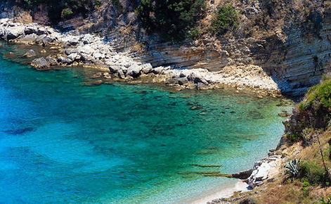
Pulëbardha Beach
Pulëbardha Beach (Plazhi i Pulëbardhes) actually means seagull’s beach. The beach is an amazing oasis that is both quiet and secluded, but still has everything you need at the same time. It’s hidden and surrounded by a rocky, but green landscape and the turquoise colored water is extremely clear. It’s a perfect place to escape the town and relax while enjoying the beautiful views.
Pulëbardha Beach is located between Saranda and Ksamil. To get there, you can take the bus that runs between Saranda and Butrint every hour. Tell the driver to stop at Plazhi i Pulëbardhes to be dropped off at the correct exit of the main road SH81. Be aware that from there to the beach, it is still a 20 minute walk. Alternatively you can take a taxi or rent a car to go around by yourself. Be aware though, that you will be driving on a dirt road when you exit from SH81 and the final part is not in a good condition and rather rocky and full of potholes so be careful when driving.
At Pulëbardha Beach there is a restaurant that is really nicely located on the rocks. From the restaurant you can look down at the clear turquoise water, but you also have

OPENING HOURS
Everyday
ADDRESS
Pulëbardha Beach, Sarandë, Albania
a great view at the beach and at Saranda’s bay. You can even see Lekursi Castle at a distance.
Further down on the beach, almost hidden behind the rocks, there is another beach bar. You can rent beach beds and umbrellas as well on Pulëbardha Beach.
Plazhi i Manastirit
Monastery Beach (Plazhi i Manastirit) is one of the most beautiful beaches located south of the town of Saranda, and before Ksamil. The beach is secluded from both sides by the hills around it, so it’s a great place to escape the busy town of Saranda or Ksamil. However, this beach can also get very crowded during the summer months.
On the hill of Dema just next to the beach there is the 14th century Monastery of Saint George, which is also worth a visit. From the hill you have amazing views at the Ionian Sea as well as Lake Butrint.
To get to Monastery Beach, you can take the bus to Butrint and ask the driver to stop at “Manastiri i Shën Gjergjit” and from there it’s a short stroll down to the beach. Off course you can also take you own transportation, rent a car or motorbike, or take a taxi from Ksamil or Saranda.
You can rent sunbeds and umbrellas at Monastery beach and there is a beach bar and restaurant called “Bar Restorant Monastery Beach”.
OPENING HOURS
Everyday
ADDRESS
Plazhi i Manastirit, Sarandë, Albania
Mirror Beach
According to the Albanians, Mirror Beach (Plazhi i Pasqyrave) is one of the best beaches in Albania. The story is that the sun reflects into the crystal clear water like a mirror, giving it a magical effect. That’s why it is called the beach of mirrors, or mirror beach.
It’s also highly rated for it’s beautiful landscape. The beach is secluded by rock formations and beautiful green surroundings.
Mirror Beach is located between Saranda and Ksamil. To get there, you can take the bus that runs between Saranda and Butrint every hour. Tell the driver to stop at Plazhi i Pasqyrave (Mirror Beach) and from there you can walk to the beach in about 15 minutes downhill. Alternatively you can take a taxi or rent a car to go around by yourself. Be aware though, that the last part is a dirt road which is rocky and full of potholes. So be careful of your car or you can walk the last part of the journey.
The great thing about Mirror Beach is that it is quiet and secluded, so it’s a great escape from Saranda or Ksamil which are obviously full of hotels. Mirror Beach doesn’t

OPENING HOURS
Everyday
ADDRESS
Mirror Beach, Sarandë, Albania
have that much when it comes to facilities, but there is one bar and restaurant on the beach. You can also rent sunbeds with umbrellas here, but off course it’s also fine to put your own towel down on the beach.
In front of the beach you can find some concrete bunkers that were built during the communist times. Like in many other places around Albania the bunkers were used to protect the coastline during the Cold War.
Mirror Beach is not only secluded by rocks, it also has some rock formations in the water to complete the view. You can easily swim to the big rock and climb on it. Behind the rock you can see Saranda and the amazing landscape of mountains behind it.
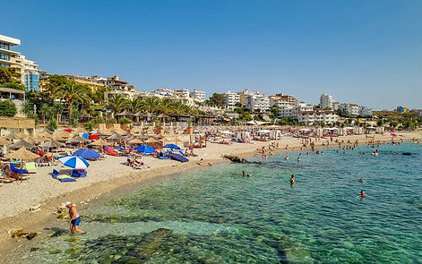
Saranda Beach
Being a beach town in the Albanian Riviera, obviously the beaches are what attracts the majority of the visitors to Saranda. Almost the entire coastline in Saranda consists of beaches, and the water is perfectly clear and turquoise. Here you find a complete guide to all the beaches in Saranda, some of which are public, and others are privately operated. We have divided the town up in three areas: the Public Beaches in the centre of town, the Beaches in Koddra in the west and the beaches alongside Rruga Butrinti in the east.
Saranda Beach is the only public beach in town, which means it is accessible by anyone for free. At the same time, it is the longest beach strip as well, stretching all the way from the Ferry Terminal until the end of the promenade on Rruga Butrinti. So basically any part of the beach in front of the boulevard is a public beach, or Plazh Publik in Albanian.
Being a city beach, Saranda Beach is obviously not the best beach in Albania and it wouldn’t be fair to compare it with any of the hidden beaches you can find elsewhere on the coast. It’s mostly full of stones and yes it can be very
OPENING HOURS
Everyday, Open 24 hours
ADDRESS
Plazhi Sarande, Sarandë, Albania
busy. Nevertheless, since the beach stretches in front of the Saranda’s town centre it has a really great vibe and the view over the entire bay is fantastic! Besides that, it’s so centrally located that you have everything around.
On the Public Beach there are some small piers that you can jump off and you can also find some ruins of the entrance gate of ancient Onhezmus.
Rruga Butrinti meanders around the coastline in the east of Saranda and is the more touristic part of town. You’ll find plenty of hotels, apartment complexes, bars and restaurants alongside the entire coast. All of the beaches in this area are privately operated, but this doesn’t mean that you can’t go there. Most of these beaches are in front of a hotel or restaurant and are free for their patrons. Sometimes they require a small fee for non-hotel guests or you need to rent a beach bed or umbrella or you’re expected you to buy a consumption.
Since you can find some of the best beaches in Saranda in this area, it’s definitely worth going here. People might argue which beach is the best, but Secret Beach, Santa Quaranta Beach and Mango Beach are definitely among the favorites.
Gjiri I Midhjeve Beach
Gjiri i Midhjeve is a beach located in a secluded bay just south of Saranda. Gjiri i Midhjeve literally means Mussel Bay.
Gjiri i Midhjeve Beach is located south of Saranda, just after passing the Bistrice river. The easiest way to reach the beach is with your own transportation, a rental car or motorbike, or by taxi from Saranda. You should take the first exit to the right after crossing the river at the sign that says Bahamas or Dodona Hotel. From there you just continue the road (don’t go to the Dodona Hotel) which turns into an unpaved road for the last part. You can park for free at the beach.
You can also take the bus between Saranda and Butrint which will drop you off at the exit of the main road from where you’d have to walk all the way to the beach.
You can rent sunbeds and umbrellas at Gjiri i Midhjeve Beach and there is a bar and restaurant to get food and drinks during your beach day. There are also a few hotels around the bay.

OPENING HOURS
Everyday
ADDRESS
Gjiri I Midhjeve Beach, Sarandë, Albania
Shpella E Pëllumbave Beach
Shpella e Pëllumbave is a small beach squeezed in between the rocks of the Ionian coast, near Ksamil in the south of Albania. The beach is located right next to Mirror Beach, but you’d have to swim around the rocks to get from one beach to the other.
To get to Shpella e Pëllumbave you have to follow Rruga Butrinti between Saranda and Ksamil and take the exit at the sign of Mirror Beach (Plazhi i Pasqyrave). From there you just follow the road until you see the sign of Shpella e Pellumbave where you take a left. You will end up at a challenging unpaved road, so be careful when driving. When you reach reach the end of the road, you need to climb down a few flights of stairs to reach the beach.
So you need your own car, rent a car or motorbike, or arrange a taxi to bring you and pick you up. The bus between Saranda and Butrint will only drop you off at the exit of the main road, from where it’s a really long and steep walk to the beach so make sure to bring plenty of water if you decide to hike all the way.
Although it’s only a small beach it can get very busy in the

OPENING HOURS
Everyday
ADDRESS
Plazhi Shpella E Pëllumbave, Sarandë, Albania
summer months and during this period you can rent sunbeds and umbrellas and there is also a bar and restaurant. Very basic toilets are also available. There are no jet skis or other water sports activities at this beach.
Edon-Bina Beach
Edon-Bina Beach is a public beach on the Albanian Riviera coast, located betweeen Saranda and Ksamil and close to Mirror Beach.
Edon-Bina Beach is located just off Rruga Butrinti between Saranda and Ksamil. The easiest way to reach the beach is with your own transportation, a rental car or motorbike, or by taxi from Ksamil or Saranda.
You should take the exit at the sign that says Plazhi i Pasqyrave (Mirror Beach) and then it’s almost directly to the right. You can best park your car at the side of the road and walk to the beach, as the small dirt road is pretty challenging.
The beach is really deserted and there are no facilities at all so make sure to bring your towel, some food and plenty of water or other drinks.

OPENING HOURS
Everyday
ADDRESS
Edon-Bina Beach, Sarandë, Albania
Monastery of 40 Saints
The Monastery of the Forty Saint Martyrs is a ruined Eastern Orthodox monastery overlooking the coastal city of Sarandë in southern Albania. The monastery was erected during the 6th century AD and possibly became for at least one millennium the most important pilgrimage site in the Ionian Sea region. The name of the monastery; Agioi Saranta was transferred to the adjacent city of Onchesmos. During the Peoples Republic of Albania, the site was transformed into a military installation. Today only a part of the side walls of its basilica type church survive.
Formerly a monastery and pilgrimage centre, today the Forty Saints Monastery is a popular tourist destination, though it is partly shattered from time and negligence. The ruins of this 6th century Byzantine monastery lie across from the bay where Lëkurësi Castle stands. Overlooking Sarandë, this monastery is a significant object of history and tradition which intricately link it to the story of the beautiful coastal city. In fact, this may be one of the only monuments of its kind in Albania and the Balkans. Declared a cultural monument of the first category in 1970, the monastery is located only a few kilometres from Saranda.

OPENING HOURS
Everyday
09:00-18:00
ADDRESS
Plazhi Shpella E Pëllumbave, Sarandë, Albania
The structure extends over the hillside and most noticeably features columns, symmetrical rows of windows and arches above them, and several halls constructed in stone. The monastery famously includes 40 rooms, one for each of the martyrs it is named after. It is thought that the church was functional until the 19th century. Though originally it had two floors, one of them was destroyed during the bombings of World War II.
The iconostasis of the church consists of a row of columns over which extends an elegantly decorated epistyle, while the stones in the bottom are all decorated throughout. Murals of Byzantine disciples adorn the walls of the monastery with one of them thought to be the oldest Byzantine mural in Albania. From the two symmetrical rows of windows, you can have a gorgeous view of the city below. A legend haunts the halls and the forty rooms of the Forty Saints Monastery. It tells of 40 Christian soldiers who were once asked to renounce their faith in exchange of shelter from a severe sea storm.
Loyal to their faith, the soldiers refused, choosing martyrdom instead by returning to the fatal storm. The setting of this story is thought to have been Sebaste, Armenia but, as with many legends, neither the story nor the setting is definite. What is certain is that the martyrs never sacrificed their faith and were thus honoured by having the monastery named after them.
St. Nicholas Monastery Church, Mesopotam
In the south of the Mesopotam village in the outskirts of Sarandë, close to the ancient city of Finiq (Phoenice), you can visit one of the world’s pearls of Byzantine architecture. One of the oldest and largest churches of the Byzantine era, St. Nicholas Monastery (Manastiri i Shën Kollit), also known as the Monastery of Mesopotam, is a must visit for just about anyone, especially those who love very well-preserved ruins and byzantine art.
Having withstood the test of time, the traces of the monastery’s centurieslong history along with its gorgeous mosaics are ready to be explored by the curious traveller. The church was built in the 11th century, specifically during the reign of Byzantine Emperor Constantine IX Monomachos which lasted from 1042 to 1055. The Orthodox Monastery consists of a typical Byzantine architecture, surrounded by the ruins of a former temple’s circular wall, built before the church. The exterior is constructed in bricks while the interior rooms are divided by gorgeous arches. In the monastery’s interior walls and columns, you will find spectacular floral designs as well as

OPENING HOURS
Everyday
ADDRESS
W442+87Q, Delvinë District, Albania
some beautiful mosaics depicting mostly animals and mythical creatures.
Four circular roofs, built one over the other, hold the grand entrance of the church’s portico while the garden sits beautifully under the shade of century-old cypresses and olive trees. Its architecture easily places the monastery in the category of rare architectural objects, and it is precisely its double apse that makes it a truly singular structure in its genre.
Synagogue - Basilica, Archeological Remains
Impressive remnants from a synagogue dating from the 5th or 6th century, C.E., in the city of Sarandë, a coastal city in Albania believed to be from the first synagogue in Albania. These remains still lie near the city centre close to Lungomare and are brilliantly incorporated into the modern Sarandë city.
The ruins are located right in the center of Saranda, next to the Friendship Park between Rruga Skënderbeu and Rruga Onhezmi. As Saranda is quite compact, the ruins are easily reached by foot. If coming from further, the bus between Saranda’s ferry terminal and Butrint is pasing by as well. All other buses and minibuses terminate right next to the ruins as well.
The ruins are the remains of the center of what was once a wealthy Jewish community that lived in the area. You can see the archaeological excavations of a 5th century synagogue complex and basilica of ancient Onhezmus.
Archaeologists believe that construction of the Christian

OPENING HOURS
Everyday, Open 24 hours
ADDRESS
Rruga Skënderbeu 7, Saranda 9701, Albania
basilica first started in the 4th century BC and that it was later transformed into a synagogue at the end of the 5th, beginning of the 6th century AD. Besides religious activities the complex has also been used as a community center and had a school for bible studies. According to archaeologists, the synagogue has undergone various periods of use, and in its last stage it was even converted into a Christian church. It is unclear what has exactly caused the destruction of the buildings. Some say it collapsed during an earthquake and others claim it was destroyed by a Slavic invasion.
Particularly interesting to see is a mosaic floor depicting Jewish symbols such as a ram’s horn, a menorah (seven branched candelabrum) and an etrog (citrus). The initial excavations of the site started in 1984 under communist rule. In 2004 additional discoveries were made and further excavation occurred by a joint Albanian-Hebrew University delegation. The newly discovered ruins are an extension on the complex by rooms with more mosaic pavings. The decorations represent a fish, different animals, trees and symbols and a shrine.
Museum of Traditions
The Museum of Traditions is located in the old Customs House in front of the marina and shows the cultural heritage of Saranda. It is a great place to learn about the history of Saranda and how it has changed over the centuries. The museum consists of several rooms over 2 floors but is rather small. Around 30-45 minutes should be enough to visit the entire museum. The entrance is only 100 lëke and the same tickets also gives you entrance to the Museum of Archaeology and Galeria Art Saranda.
At the start of the exhibition you see a sketch from the 19th century British poet and artist Edward Lear next to a 1930 photograph showing how only 8 out of 20 stone watchtowers were remaining at that time. On the walls of the ground floor, you see more photographs of Saranda over time. The images show how Saranda has developed over the centuries.
In the 1930s the city was built on a grid system and buildings were deliberately kept low-rise so the entire city could be seen from the see, looking like rising seats in a theatre.
You can also see photographs of the Monastery of 40

OPENING HOURS
Monday-Friday, 08:00-15:00
Saturday, 10:00-15:00
ADDRESS
V2F5+MMF, Sarandë, Albania
Saints from before its destruction during World War II. Even though little is left after the bombardment, you can still visit the remaining ruins.
Apart from the images a collection of everyday objects from different times are displayed on the first floor.
St. George's Monastery
The Monastery of Saint George (Manastiri i Shën Gjergjit) consists of a reconstructed church from the 14th century, within the walls of a monastery complex. It is located on the hill of Dema and offers stunning views over the Ionian See on one side, and the Butrint Lake to the other side. Down the hill there is also Monastery Beach, one of the best beaches in Saranda.
The complex is located halfway between Saranda and Ksamil. You can take the bus to Butrint and ask the driver to stop at the road that leads to the monastery. There is a sign that says “Manastiri i Shën Gjergjit” and from there it is a short, but steep walk up the hill. For more convenience you can also book a tour, take a taxi or rent a car.

OPENING HOURS
Everyday
ADDRESS
Manastiri i Shën Gjergjit, Ksamil, Albania
Ksamil
The Ksamil Islands transport you to a tropical paradise, with the breathtakingly turquoise waters, sandy beaches, and natural tranquillity so sought-after by beach-going enthusiasts. Beautifully concluding the Albanian Riviera is the village of Ksamil, which happens to be one of the best surprises Albanian tourism has to offer.
Thanks to the especially clear and brisk waters of the famous islands of Ksamil, and its proximity to the ancient city of Butrint, a UNESCO Heritage Site, this place has attracted the special attention of international media, which have listed it as one of the European Southern Destinations you should not miss. There is a total of four spectacular islands in Ksamil.
The most famous ones are the Twin Islands, which are connected to one another via a narrow sand belt. However, they each have their own individual beauty and charm, and are both worth visiting – being easily reachable from the shore! The perfect tranquillity and dense greenery of these islands resemble a tropical paradise which you won’t want to leave. Here, you can go canoeing, diving, or book a boat trip.

OPENING HOURS
Everyday
ADDRESS
Ksamil, Saranda, Albania
The delicious seafood dishes served in the numerous restaurants of Ksamil, and the tasty cocktails, which can be enjoyed under the sun, are some more reasons you’ll thoroughly enjoy your time here. Splash in these waters to your heart’s delight, take snaps of this photogenic paradise, and take a Mussel Tour whilst you’re in the area. This innovative and charming tour was created by a local youngster and has been a big hit in the last couple of years.
Ksamil Islands
There are a total of four spectacular islands in Ksamil. The most famous ones are the Twin Islands, which are connected to one another via a narrow sand belt. However, they each have their own individual beauty and charm, and are both definitely worth visiting – being easily reachable from the shore! The perfect tranquility and dense greenery of these islands resemble a tropical paradise which you won’t want to leave!
Here, you can go canoeing, diving, or book a boat trip. The delicious seafood dishes served in the numerous restaurants of Ksamil, and the tasty cocktails, which can be enjoyed under the sun, are some more reasons you’ll thoroughly enjoy your time here.
Splash in these waters to your heart’s delight, take snaps of this photogenic paradise, and definitely take a Mussel Tour whilst you’re in the area! This innovative and charming tour was created by a local youngster, and has been a big hit in the last couple of years.

OPENING HOURS
Everyday
ADDRESS
Ksamil, Saranda, Albania
Gjiri I Hartës Beach
Gjiri i Hartës is a secluded beach in a bay near Ksamil on the Albanian Riviera coast. The beach has a small public part where you can just put down your towel, as well as a large privately operated beach. From the beach you can see the local fishermen at work with the large fishing traps and on the horizon you can see Ksamil and the Ksamil Islands.
You can reach Gjiri i Hartës via the road between Saranda and Ksamil, from where you exit just before Ksamil, passing by the local fish market. Parking is free at the beach so the easiest way to get there is with your own car, rental car or motorbike, but taxis from Saranda or Ksamil will also bring you there and pick you up. You can also take the bus between Saranda and Butrint which will drop you off at the exit of the main road. From there you can already see the beach, so it’s not that far of a walk.
Since Gjiri i Hartës is largely operated privately there are plenty of facilities. There is a bar and restaurant, there are modern toilet facilities and some changing rooms.
You can also rent sunbeds and umbrellas and there are

OPENING HOURS
Everyday
ADDRESS
Gjiri I Hartës, Ksamil, Albania
some piers from which you can jump into the water. You can also go on a boat trip or rent a peddle boat or jet ski.
Pema E Thatë Beach
Pema e Thatë is a privately operated beach located almost as south as you can get in Albania. The beach consists of several small secluded bays that are hidden behind the forests of the Butrint National Park. The environment is really beautiful despite that the beach can get really busy in summer. From the beach you can see the Greek island of Corfu which is so close that you could almost swim to it.
Pema e Thatë is remotely located and can only be reached via a small, partly paved road through the forest from Ksamil, or by boat. So you need your own car, rent a car or motorbike, or arrange a taxi to bring you and pick you up.
At the beach you can rent sunbeds and umbrellas or even splurge yourself with one of the beach tents hanging above the water for an amazing view. There are several bars and there is a restaurant and pizzeria so you’ll have plenty of options for food and drinks and there are also toilets and changing rooms.

OPENING HOURS
Everyday
ADDRESS
Pema E Thatë, Ksamil, Albania
The Blue eye
A popular tourist attraction, the clear blue water of the river bubbles forth from a depth of more than fifty metres. Divers have descended to fifty metres, but it is still unclear what the actual depth of the karst hole is. This phenomenon is also known as springs of Bistricë as it is the initial water source of Bistricë river, 25 kilometres long, which ends in the Ionian Sea south of Sarandë.
The source stands at an altitude of 152 metres. As unexpectedly spectacular as the coast of Southern Albania. The country hides its own small tropical paradise, aptly called the Blue Eye, Syri i Kaltër. Perhaps the most breathtakingly beautiful sight in Albania, the Blue Eye is located about a 30-minute drive away from the coastal city of Sarandë on the road to Gjirokastra.
The landscape leading to the Blue Eye uncovers this anomaly of nature as you will find yourself surrounded by palm trees, wild ferns and tropical plants, as well as dense, mountainous forest vegetation of oaks and sycamores, all at once. This vegetation is kept lush and glorious by the spring flowing down the mountain into the Bistrica River. A total of eighteen springs are dispersed along the site!

OPENING HOURS
Everyday
09:00-18:00
ADDRESS
Sarande SHA22, Sarandë 9701, Albania
The freshwater spring from the Gjerë Mountain flows into the Blue Eye and creates a natural pool with depths of about 50 meters. The actual depth has not yet been determined, many divers have tried to get to the bottom of it, to no avail. This Blue Eye is intense, as you look into the centre of this pool, you will begin to understand where the place gets its name.
The deep blue sapphire waters of the centre form the pupil of the eye and are surrounded by the vibrant emerald greens, teals, and turquoise of the iris. The eyelashes are formed by the surrounding vegetation. The waters, though deep and blue, are so crystal clear that they reveal the rocks and vegetation at the bottom. The water maintains an “only for the brave” temperature of no more than 10 degrees Celsius (50 degrees Fahrenheit). During the summer, many challenge the cold-water temperatures by diving straight into the centre of the “eye.”
The Blue Eye is an oasis of fresh air and cool climate, a tropical paradise that can rival any in Maldives. In the summers, it provides a shelter from the relentless sun of the southern coast. Alternatively, after the cool dip into the Blue Eye, you will want to revisit the warmth of the Ionian, where the Blue Eye also flows into. Lonely Planet calls it magical and hypnotic, Atlas Obscura breathtaking and mesmerizing. Those who have had the fortune of seeing the Blue Eye have felt god-like and omnipotent.
Butrint
The Butrint National Park is a national park in southern Albania, located 18 kilometres south of Sarandë in Vlorë County. The park encompasses 9,424 hectares of hilly terrain with freshwater lakes, wetlands, salt marshes, open plains, reed beds and islands. The park’s significance for conservation is reflected in the large number of species with over 1,200 different animals and plants. Its mandate includes the protection of the lake and lagoon of Butrint, the natural channel of Vivari, the islands of Ksamil and as well the archaeological site, that provides valuable remains of ancient civilizations. Butrint is strategically located in the eastern part of the Strait of Corfu in the extreme south of the country.
It sprawls across a peninsula that is surrounded by Lake Butrint and Vivari Channel. The channel connects the lake to the Ionian Sea through a narrow sandy bar. Located in the direct proximity to the sea, the park experiences mild Mediterranean climate. This means that the winters are mild, and the summers are hot and dry. Hekateus made first mention of the city at the end of the sixth century B.C., affirming that the city was built according to Troy and that the origin of the name refers to the sacrifice of a bull, Buthrotos, provided by the Trojan prince Aeneas on his

OPENING HOURS
Everyday
09:00-19:00
ADDRESS
SH81, Butrint, Albania
way to Dodona.
During its early period, Butrint was the center of the Kaonic tribes, later to become part of the kingdom of Epirus. Of the countless antique ruins and landmarks of Albania, Butrint is the one most responsible for putting Albania on the map. Butrint’s glorious 2500-year-old ruins, within a majestic 30 km wide natural reserve, are some of the most well-preserved in Europe. In 1992, Butrint was declared a World Heritage Site by UNESCO and it sits comfortably at the top of every international list of must-sees in Albania. Yet, for all the interest that this beautiful place arouses, it has somehow remained an oasis of rare tranquillity.
You can walk freely here, bypassing the long lines or similar hindrances commonly associated with these rare sights. Well-preserved monuments reflect each distinct stage of its rich history, starting from the Hellenistic period and continuing to the Roman, Byzantine and Venetian periods. Each has left its own beautiful trace on this place. Though life in Butrint had started long before, the influence of Hellenic culture in Albania officially began in the 6th century B.C. when Greeks from the island of Corfu settled on the hill of Butrint.
According to mythology, the city’s antique name of Buthrotum comes from the word buthrotos, meaning “the wounded bull,” which refers to the Trojans’ sacrifice of a bull when they established the town on the hill. Even the great ancient Roman poet, Virgil, tells of Aneasus in Buthrotum in his famous epic poem Aeneid. The entrance to the ancient city displays one of this period’s best-preserved Hellenic masterpieces: the Greek Theatre (3rd century B.C.) which could once sit 2500 people and which, to this day, houses the most spectacular performances, faithfully reflecting its former glory.
Near the theatre stand the ruins of the Temple of Asclepius (1st century), the ancient god of health and the city’s defender. When the Romans arrived in Butrint, around the 2nd century B.C., the most significant monuments in the city had already been completed, including the fortification and the Acropolis, built centuries ago atop a hill. With the entrance of the Roman Empire in 44 A.D., Butrint saw a series of additional constructions which today illustrate early Christianity in Albania. Please note: The ancient columns and the floor mosaic composed of 69 church medallions, represent two of the most beautiful sights in the entire country.
Further on, we have the magnificent walls of the 6th century basilica and its intricate mosaics, the fortifications up the hill dating back to various centuries, and the imposing Lion’s Gate (5th century A.D.), which displays the relief of a lion gnawing at a bull’s throat, an image symbolizing the city’s fierce defence. The very top of the hill house a castle from the city’s Venetian period, built where the ancient acropolis was. The castle was originally built in the 14th century and was identically reconstructed in 1930. Today, this castle houses the Museum of Butrint. It is the view from the top of this hill that represents Butrint’s last spectacular gift, the Lake of Butrint, the Vivari channel linking the Butrint Valley to the Ionian Sea, the nearby Castle of Ali Pasha, and the dense forests enveloping the landscape.
Ali Pasha Castle of Butrint
Ali Pasha Castle is a castle in Albania. It is named after Ali Pasha of Tepelenë who resided there until 1820. The current fortress was rebuilt in 1819 from its surface with 3 towers. Until 1820 it was the second residence of Ali Pashe Tepelena. Built under Venetian dominion in the late 15th or early 16th century, it provided a stronghold for the Venetians on Corfu to exploit fishing, grazing, olives and timber in and around Butrint.
The castle was the centrepiece of numerous conflicts with the burgeoning Ottoman Empire, and changed hands on several occasions. It was destroyed by a retreating French army in 1798 to prevent it falling into the hands of Ali Pasha. The fortification attributed to Ali Pasha at Butrint lies some 2.4 kilometres (1.5 mi) due west at the mouth of the Vivari Channel. This in itself began life in the late 17th or early 18th century as a fortified estate centre belonging to a Corfiote family that farmed land on the plains south of the ancient city.
Ali Pasha seized control of the structure around 1804 and carried out a series of defensive improvements including the installation of gun batteries. Given its small size it is

OPENING HOURS
Everyday, Open 24 hours
ADDRESS
Vivari Channel, Ksamil, Vlora County, Albania
unlikely that the fort functioned as anything more than a control over access from the sea to Butrint, and it can not be compared to Ali's more redoubtable fortresses in the region at Tepelena, Gjirokastra and Ioannina.
Monastery Of Kamena
The Monastery of Kamena is a manastery and church on the slope of Mount Sopot, located about 2 kilometers from Delvina.
The monastery is thought to have been first built in 630, but reconstructions also took place in 1032 and 1580. The church is dome-shaped with a cross and consists of a nave, narthex, altar, and a vestibule and has a double roof.

OPENING HOURS
Everyday
ADDRESS
Monastery Of Kamena, Delvina, Albania
Libohova Castle
Libohova Castle (Kalaja e Libohovës) is a castle in the village of Libohova. It was built between 1796 and 1798 and is one of the many fortifications that were erected by the Ottoman ruler Ali Pasha of Tepelena, who dedicated the castle to his sister Shanisha. From the castle you have some spectacular views over the Drino valley on one side, and on the other you look up to the slopes of the Bureto Mountain.
The castle itself has an almost rectangular shape and measures about 70 meters long and 50 meters wide. Its walls are up to 1.40 meters wide and each corner has a polygonal tower. In the center of the castle is a small entrance that leads to a concrete underground bunker.
The castle is located in the village of Libohova, about 20 kilometers from Gjirokastra and can best be reached by car. If you don’t have your own transportation you can rent a car or alternatively take a bus from Gjirokastra.

OPENING HOURS
Everyday, Open 24 hours
ADDRESS
Kalaja e Libohovës, Libohovë, Albania
Monastery Of Saint Mary, Kostar
Kostar is a tiny village on the slopes of the mountain. The Monastery of Saint Mary is beautifully built at the face of a steep cliff, which makes it a very special location for a monastery. The building is literally carved out of a rock and has a spectacular view over the surrounding valley and villages.
The monastery dates all the way back to 1332 when the first parts were built. The monastery was later extended between 1690-1770. So the building is really old but very beautifully decorated with wall paintings and wooden furniture, so not surprisingly it’s considered as a pelgrimage site by many.
Kostar and its monastery are located just off the SH99 road between Saranda and Gjirokastra and is best reached by car. From Saranda it takes about 30 minutes to get there, but be aware that from the main road, you have to drive for about 4 kilometers over a small and steep road that is only partly paved and can be quite challenging at some points. You can drive all the way up to the

OPENING HOURS
Everyday
ADDRESS
Kostar, Vlore County, Albania
monastery and park there.
If you don’t have your own transportation you can rent a car or motor cycle, or arrange a taxi to get you there. Alternatively you can take any bus from Saranda to Gjirokastra and ask to be dropped off the exit towards Kostar, which is just after the village of Mesopotam. Bring plenty of water, because you’d need to walk for about 4 kilometers uphill and all the way back as well.
Gjin Aleksi Mosque
The Mosque of Aleksi Gjin is located in the village of Rusan, close to Delvina and about 16 kilometers from Saranda. It was built in the 15th century and a thorough restauration took place in 2008.
The mosque is now considered a cultural monument, but is still being used for religious practices. The best way to get to the Gjin Aleksi Mosque is by car. If you don’t have your own transportation you can rent a car or motor cycle, or arrange a taxi to get you there.
Alternatively you can take any mini bus from Saranda to Delvina and aks the driver to drop you off at Rusan road, from where you can easily walk to the mosque.

OPENING HOURS
Everyday
ADDRESS
X32G+PHC, Rusan, Albania
Delvina Castle
What’s left of the castle of Delvina (Kalaja e Delvinës) are some ruins on a hill top next to the village. From the hill you have some spectacular views over the village of Delvina and the surrounding valleys and mountain ranges.
The Ottoman traveler Evliya Çelebi visited Delvina around 1670 and describes the ancient city in his book. The city is thought to have been in Spanish and Venetian hands before the Ottoman occupation and it’s unclear when the castle was built exactly.
Today, there is not much left of the castle, exept some of the fortification walls and the walls of a mosque dating back to the Ottoman period. The communists have also added some concrete bunkers on the hill during the Cold War. According the memoires by Çelebi the castle had a cistern an ammunition depot and a mosque. The city counted about 100 houses, about 80 stores, an open market place and three Medreses.
The best was to reach the castle in Delvina is by car and then hike up the hill. Be aware that there are no signs or official paths, but once you see the castle, it’s easily reached by foot.

OPENING HOURS
Everyday, Open 24 hours
ADDRESS
Rruga Ali Pashe Tepelena, Delvina, Albania
Phoenice Archaeological Park
The Phoenice Archaeological Park (Parku Arkeologjik Finiq) is an archaeological excavation of an ancient greek city located next to the village that is nowadays Finiq.
Phoenice (also called Phoenike or Φοινίκη in Greek) was the capital of the Greek tribe of the Chaonians and was once the wealthiest city in the Epirus. Due to its strategic location and economic development the city played an important strategic role from a political and administrative perspective.
The first structures date back to the 5th century BC, when the building of an acropolis started to house a number of public buildings. In the following century the fortifications were extended and blocks of up to 3.6 meters thick were used to defend the city. After several conflicts the Treaty of Phoenice was signed to end the First Macedonian War in 205 BC.
Under the Byzantine influence in the 5th and 6th centuries more religious buildings were erected, including a baptistery and a basilica and fortifications were built on the adjacent hill. After the 6th century the city got in decline when the urban city was moved to nearby Mesopotam.

OPENING HOURS
Everyday
09:00-18:00
ADDRESS
Phoenice Archaeological Park, Saranda, Albania
The urban area of Phoenice has been surrounded by higher walls that followed the slopes of the hill with obvious ups and downs, forming an ellipse-shaped layout. The earliest phase of this fortification dates back to the middle of the 4th century BC, when the urban area was limited on the east side of the hill.
The blocks used in this first period are enormous. The second period dates back to the middle of the 3rd century BC, when the urban area was extended in the center and west side of the hill, and was built with smaller blocks. Polybus wrote “Phoenice is the richest city, the most fortified, and the most powerful of the Epirus” which is proved very well by the existing ruins.
This incredibly powerful fortification system, in combination with the strategic position of the hill giving a 360 degrees view, gave Phoenice the character of a great political service center of Chaonia and the Epirus.
During Roman times renovations took place and new buildings were added to the town of Phoenice. A work of this period related to the water supply system of the town is Cistern A. Labeled as such by the first digger of Phoenice, the Italian archaeologist Luigi M. Ugolini, this cistern was built within the walls of the Hellenistic tarrace. Cistern A has a rectangular form and was severely damaged by the construction of a military facility within its structure during the communist times.
The theater is the most identifying monument of the ancient city of Phoenice. It not only reflects two main stages of this city, the Hellenistic and the Roman period, it also stands out for its large dimensions, attesting to the importance of this great political capital.
The orchestra occupies a large artificial terrace in the western slope of the hill. The cavea is geared totally in the natural terrain that forms a semi-circular beam, ideal for building seats. The theater was used for performances and probably for political reunions of the Epirote federation (Koinon).
Based on architectural structures and archaeological material, consisting of black-glazed pottery and artwork that decorated the stage, the theatre dates back to the middle of the 3rd century BC. During the 3rd century AD Roman period the theatre was reconstructed.
According to the ancient author Procopius of Caesarea, Phoenice was rebuilt by the Byzantine Emperor Justinian I (527-565 AD). This is proven by the architectural style of the basilica that was built next to the Hellenistic “Thesaurus”. Recent excavations have shown that this church was extremely large in size, consisting of three naves and transept, an apse, narthex and atrium.
The church dates back to the 5th or 6th century AD and collapsed in the 13th century after which the area was used as a cemetary until the 16th century. The structure was further damaged during the communist regime.
Due to its strategic location, the hill was used as a military base by the communist regime during the Cold War. Unfortunately this resulted in more damage to the archaeological remains. The communists built several bunkers that you can still find throughout the hill. At the southern end of the site, the are a couple of bunkers that are connected by tunnels.


