Summer Flight Timetable for Flights to Albania
(Version 5 Effective 05 March 2021)

FERIZAJ
Where Mountains Roam the Land!
Sharr Mountains National Park/ Prevalla National Park
The Sharr Mountains National Park or Prevalla National Park is a national park in south-eastern Kosovo. It covers 53,272 hectares, cantered on the northern Sharr Mountains, a mountain range which also extends into north-eastern Albania and north-western North Macedonia. The park encompasses various terrains, including glacial lakes, alpine and periglacial landscapes. The Sharr Mountains National Park has an alpine climate, with some continental influence.
The mean monthly temperature ranges between −1.3 Degrees Celsius and 20 Degrees Celsius, whilst the mean annual precipitation ranges between 600 millimetres and 1,200 millimetres depending on elevation. The flora of the park is represented by 1,558 species of vascular plants. The fauna includes 32 species of mammals, 200 species of birds, 13 species of reptiles, 10 species of amphibia, 7 species of fish and 147 species of butterflies. In terms of phytogeography, the Sharr Mountains National Park belongs to the Illyrian province of the Circumboreal Region within the Boreal Kingdom. It falls entirely within the Balkan mixed forests terrestrial ecoregion of the Palearctic Temperate broadleaf and mixed forests.

The City of Ferizaj
The city has been populated since the prehistoric era by the Starcevo, Vinca and Baden culture. During the Ottoman period, Ferizaj served as a trading centre on the route between Belgrade and Thessaloniki. Ferizaj has always been considered as a city where tolerance and coexistence in terms of religion and culture has been part of the society in the last centuries. The town, was named Ferızovık when it was part of the Ottoman Empire, was little more than a village until 1873, when the Belgrade-Thessaloniki railway was opened, passing through the town.
The name derives from a pre-1873 hotel owned by a local named Feriz Shasivari. The oldest ethno-cultural group who lived in the 6th and 5th millenniums BC in the territory of Kosovo was the Starcevo culture. Members of this group constructed their homes near rivers and the river terraces. They made their homes of willows and mud, while their main profession was ploughing and farming. Starting from the 8th century BC and then during the next centuries, until the Roman conquest, can transmit continuously development of a new culture in the region, the Dardanian tribe. The Dardanian burned their dead and bury their remnants in tumuli tombs.
In the city, two necropolis have been found, one in the locality of Kuline near the railway station in Gërlicë, the other in region of Mollopolc, along the Ferizaj-Štimlje road. After the Austrian-Turkish wars of the late 17th century and the first half of the 18th century, major ethnic changes occur and begins the rapid Islamization from Ottoman Empire. Until the construction of the railway from Skopje to Mitrovica, according to Turkish sources they didn't found a residence called Feriz-Bey (Ferizaj). At the beginning it was called "Tasjon" by surrounding villagers by the Turkish pronunciation of French word Station, but the name Ferizaj is obtained by Feriz Shasivari. Its rapid development starts with construction of the railway station and within a short period become the city with inns, warehouses, and permanent market.
Traffic, traders of Kosovo from Prizren to Shkodër, which at that time was by caravan, was mainly diverted toward Thessaloniki. Exporting raw materials especially that of cereals went through Ferizaj and through aligned foreign goods turnover came from Thessaloniki and Skopje. This was the reason that Ferizaj for a period of thirty years become the city with about 400 houses and 200 shops. Most of the population work in trade, crafts and other activities related to trade.
During this period, the opening of the colonial shops, craft workshops so accelerated development of the city enough that some passengers of the 20th century describing how the city at that time resembled and at that time the city had more stores than houses. The city suffered some damage during the 1999 Kosovo War, with some of its Albanian-populated neighbourhoods being shelled and burned by the Yugoslav Army. Following the war, the city has seen serious inter-communal unrest, which has resulted in almost all of the Serbians, and other non-Albanian inhabitants, either being expelled or fleeing. The Serbian churches of St. Nicholas and St. Stephen were destroyed in 1999.


Brezovica Nature & Ski
Brezovica is a unique ski resort located on the northwest part of Sharr Mountain at an altitude of 900-2,520 meters. Favourable climate conditions make this region suitable for tourism, sport and recreation during the whole year. The ski resort possesses 14 pistes, five chair lifts and five ski lifts, connected with 16 km of ski slopes of the average length 3 kilometres. The most well-known hotels in Brezovica are: Hotel Narcis, Hotel Molika, Hotel Breza, Shtepija e Gurit and Woodland Hotel.
In addition, there are also rentable private houses where you can accommodate yourself. The ridge line spans 39,000 hectares of high alpine mountain terrain and forests, with a highly diverse and abundant flora and fauna. Located within 90 minutes of Prishtina International Airport and Skopje International Airport, the Brezovica resort area represents one of the last remaining under-developed ski resort areas in Southeast Europe. Inside of this area are ski slopes with average length of about 4 kilometre, 2 miles.
The station of the outline with the exit from the cable car, is at a height of 2,212 meters above sea level. Ski centre Brezovica is open for skiing during the seasons, where in summer its surface is covered with snow, with a low exploitation possibility. Wide ski terrains of the Ski Centre Brezovica are made of a system that includes: five chair lifts and 5 ski lifts, connected with 16 kilometres, 10 miles of ski slopes of the average length 3,000 meters. On Brezovica FIS slopes for slalom, giant slalom, downhill race and “Super G” simultaneously could ski 50,000 skiers. Located on the slopes of Sharr Mountains, it is mainly a destination for skiing and snowboarding. In the summer, ecotourism opportunities include hiking, mountain biking, golf, and other outdoor recreational activities. Hiking paths can lead the visitors to the nearby Livadicko Lake. A number of successful national and international competitions are held at the resort. A number of Kosovo winter sport teams train at the resort.


Ljuboten
Ljuboten or Luboten is a peak of the Sharr Mountains located on the border between Kosovo and North Macedonia. Its elevation is 2,498 metres. Ljuboten, although not the highest peak of the range, is somewhat isolated from the rest of the mountains, making it visible from both Pristina and Skopje. The majority of Ljuboten, the north, north-west, east, and south-east sides are located within Kosovo.
On the Macedonian side of the peak there is a mountain house called Ljuboten, as well as Shija Ljubotenska, Kozja Karpa, Shiljast Kamen, and Rogacevski Korita. Ljuboten is a popular destination for mountain climbers in Europe. The mountain is covered with pastures along with rocky outcroppings. Livadh Lake in Kosovo and a few sheepfolds are near the peak. In winter there is usually over a meter of snow. The mountain house at Ljuboten is located in the foothills of the peak, connected with a road to Vratnica.

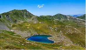
Livadh Lake
Livadh lake is a mountain lake in the Sharr Mountains in Kosovo. It lies at an elevation of 2,173 metres above sea level and has a maximum length of 228 metres and a maximum width of 120 metres. It has a great depth for a mountain lake, with 7.3 metres being the maximum depth. It is probably the most beautiful and popular lake in the entire Sharr Mountains and is a big tourist attraction. Depending on season its surface can change from 1.3 to around 2 hectares. It is next to the Tumba Peak and Maja Livadh peaks.